Best Hiking Trails in North Salt Lake, Utah 84054
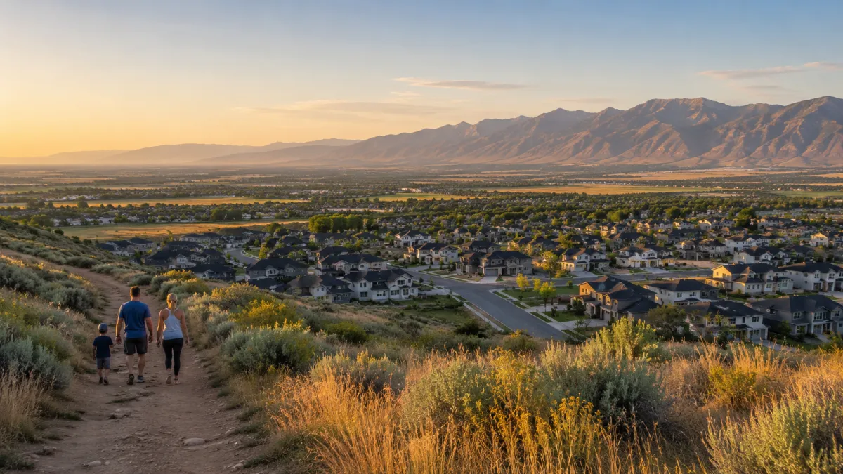
North Salt Lake, Utah has more outdoor access than many people realize. For a city located so close to Salt Lake City and Davis County conveniences, North Salt Lake gives residents quick access to foothill trails, family-friendly walking paths, paved biking routes, sunset viewpoints, and connections into the larger Bonneville Shoreline Trail system.
If you live in or near the 84054 ZIP code, you do not have to drive far to enjoy the outdoors. Many of these trails are right in the foothills above local neighborhoods, making them easy to use before work, after work, on weekends, or when you just need a quick reset outside.
North Salt Lake officially lists several local trails, including Wild Rose, Lower Wild Rose, Tunnel Springs, Springhill Geologic Trail, Bonneville Shoreline connections, Legacy Parkway Trail, and Hatch Park Loop Trail.
Below is a breakdown of the most popular trails in and around North Salt Lake, including difficulty level, what each trail is best for, and what makes each one stand out.
Wild Rose Trail
Difficulty: Easy to moderate
Best for: Families, quick hikes, foothill views, beginner-to-intermediate hikers
Trail type: Loop-style foothill trail
Approximate distance: About 2 miles, depending on the route
Estimated time: About 1 hour
Elevation gain: Moderate, around 300+ feet depending on the route
Wild Rose Trail is one of the best-known trails in North Salt Lake. It is a favorite among locals because it gives you a real foothill hiking experience without requiring a long drive or a huge time commitment.
This trail is popular with hikers, trail runners, mountain bikers, and families. It has enough elevation to feel like a workout, but it is still approachable for most people. That makes it one of the best “everyday” trails in North Salt Lake.
What stands out about Wild Rose Trail is the balance. It is short enough for a quick hike, but scenic enough to feel rewarding. You get foothill terrain, open views, and that feeling of being above the neighborhoods without needing to spend half the day on the trail.
For residents of North Salt Lake, this is the kind of trail that becomes part of your weekly routine. It is great for a morning hike, an after-work walk, or a casual weekend outing with family.
Best way to describe it:
Wild Rose Trail is one of North Salt Lake’s signature local hikes. It is easy enough for beginners, but still gives you views, elevation, and a real outdoor experience.
Wild Rose Loop
Difficulty: Moderate
Best for: Hiking, trail running, a stronger workout, local views
Trail type: Loop
Approximate distance: About 3.5 to 4 miles
Estimated time: Around 2 hours
Elevation gain: Higher than the shorter Wild Rose route
Wild Rose Loop is a better option for people who want a little more distance and more of a workout. It uses the same general trail area as Wild Rose, but the loop gives hikers more mileage and more climbing.
This trail is still very doable for most active people, but it feels more like a real hike than a short neighborhood trail. The extra elevation makes it popular with trail runners and locals who want a convenient fitness hike close to home.
The views are one of the best parts of this route. As you climb, you get a better look over North Salt Lake, the valley, and the surrounding foothills. It is especially nice in the morning or evening when the light is softer.
Wild Rose Loop is also a good option for people who have already done the shorter Wild Rose Trail and want to take the next step up.
Best way to describe it:
Wild Rose Loop is the “let’s get a better workout” version of Wild Rose. It is still local and convenient, but it gives you more distance, more climbing, and better views.
Lower Wild Rose Trail
Difficulty: Easy to moderate
Best for: Short walks, neighborhood access, trail connections, mountain biking access
Trail type: Connector-style trail
Approximate distance: Varies depending on route
Estimated time: Varies
Lower Wild Rose Trail is best understood as part of the larger Wild Rose trail system. It may not be the trail people drive across town for by itself, but it plays an important role for locals because it helps connect neighborhoods and access points into the foothill trail network.
For people who live nearby, this is a very useful trail. It gives residents a way to access the Wild Rose area without always needing to start at the main trailhead. It is also used by mountain bikers as part of a larger trail connection.
For hikers, Lower Wild Rose is a good option for a lighter outing, a short walk, or a way to connect into longer routes. It is not as much of a destination hike as Wild Rose Loop or Wild Rose to Lookout Point, but it is part of what makes the North Salt Lake trail system so accessible.
That is one of the best things about living near these trails. You are not limited to one trailhead or one route. There are multiple ways to get into the foothills and build a walk or hike that fits your time and energy level.
Best way to describe it:
Lower Wild Rose Trail is a practical local connector. It gives nearby residents easy access to the Wild Rose trail system and helps make the foothills feel connected to the neighborhood.
Wild Rose to Lookout Point
Difficulty: Easy to moderate
Best for: Sunset views, short climbs, quick reward hikes, scenic overlooks
Trail type: Out-and-back
Approximate distance: About 2 miles
Estimated time: Around 1 hour
Elevation gain: Moderate
Wild Rose to Lookout Point is one of the best short hikes in North Salt Lake if you want a view without committing to a long trail.
This route gives you a clear reward. You climb enough to feel like you earned it, and then you get a scenic viewpoint overlooking the valley and surrounding area. That makes it a great option for sunset hikes, quick evening outings, or visitors who want to experience the foothills without doing a full-day hike.
The trail is popular because it fits into real life. You can do it after work, before dinner, or on a weekend morning when you do not have hours to spare.
It is also a great trail for people who want to start hiking more often but are not ready for long, steep canyon routes. It gives you the feeling of a real hike without being overwhelming.
Best way to describe it:
Wild Rose to Lookout Point is a short reward hike. It is perfect when you want views, fresh air, and a little climb without spending your whole day on the trail.
Tunnel Springs Loop Trail
Difficulty: Easy
Best for: Families, walking, beginner hikes, casual outdoor time
Trail type: Loop and open foothill walking area
Approximate distance: Varies depending on route
Estimated time: Usually short and flexible
Tunnel Springs is one of the most useful outdoor areas in North Salt Lake. It is not just a trail. It is also a park and trail access point, which makes it easier for families and casual walkers to enjoy.
The Tunnel Springs area has open foothill terrain, wide views, and relatively easy access. It is a good place for people who want to get outside without doing a difficult hike. Families, kids, beginner hikers, dog walkers, and casual walkers can all enjoy this area.
One thing that stands out about Tunnel Springs is the open space feeling. The terrain is less wooded and more exposed, so you get big sky, rolling foothills, and views of the surrounding area.
Because of the park setting, Tunnel Springs can be more convenient than some other trailheads. It is a good place to start if someone is new to hiking in North Salt Lake or just wants a comfortable, low-pressure outdoor option.
Best way to describe it:
Tunnel Springs Loop Trail is one of the best casual outdoor spots in North Salt Lake. It is easy, open, family-friendly, and a great starting point for exploring the local foothills.
Tunnel Springs to Bonneville Shoreline Trail
Difficulty: Moderate
Best for: Longer walks, trail running, mountain biking, connecting into bigger trail systems
Trail type: Connector route
Approximate distance: Varies depending on how far you go
Estimated time: Flexible
Tunnel Springs to the Bonneville Shoreline Trail is where the local trail system starts to feel much bigger.
From Tunnel Springs, hikers, runners, and mountain bikers can connect into the Bonneville Shoreline Trail system. That means you can start in North Salt Lake and extend your route into a much larger network of foothill trails.
This route is more moderate than the simple Tunnel Springs Loop. Once you connect into the Bonneville Shoreline Trail, you can expect more distance, more exposure, more climbing, and more shared trail use with bikers and runners.
The biggest advantage of this trail is flexibility. You can keep it shorter if you just want a moderate outing, or you can extend it if you want a longer hike or run.
This is one of the trails that shows how connected North Salt Lake really is. You are not just limited to small neighborhood trails. You have access to a regional foothill system right from the city.
Best way to describe it:
Tunnel Springs to Bonneville Shoreline Trail is a great option when you want to turn a local walk into a bigger outdoor adventure.
Springhill Geologic Trail
Difficulty: Easy to moderate
Best for: Families, education, geology, short walks, nature learning
Trail type: Loop
Approximate distance: About 1 mile
Estimated time: Around 30 minutes
Springhill Geologic Trail is one of the most unique trails in North Salt Lake because it is not just about hiking. It is also about understanding the land.
This trail is located in an area with real geologic history. Springhill Geologic Park was created after landslide activity affected homes in the area over a period of years. Instead of simply leaving the land unused, the area became an educational open space where visitors can learn about geology, land movement, drainage, and the natural forces that shape the foothills.
That makes this trail especially interesting for families, students, and anyone who enjoys learning while they walk.
The trail itself is short, so it is not a difficult hike. It is better described as an educational nature walk than a serious mountain trail. Still, it gives people a reason to slow down and notice the landscape in a different way.
You may see signs of land movement, old landscaping remnants, drainage features, and other clues that tell the story of the area.
Best way to describe it:
Springhill Geologic Trail is a short educational trail that teaches visitors about North Salt Lake’s geology and landslide history. It is one of the most interesting hidden gems in the city.
Hatch Park Loop Trail
Difficulty: Easy
Best for: Walking, strollers, kids, families, neighborhood laps
Trail type: Paved park loop
Approximate distance: Less than half a mile
Estimated time: Short and easy
Important note: Check current park status before visiting because Hatch Park has had renovation-related closures.
Hatch Park Loop Trail is different from the foothill trails. This is not a mountain hike. It is a short, paved neighborhood walking loop located around Hatch Park.
When open, this type of trail is perfect for families, parents with strollers, kids, seniors, dog walkers, and anyone who wants a flat, easy place to walk.
The value of Hatch Park Loop is convenience. Not every outdoor experience needs to be a climb into the foothills. Sometimes people just need a clean, simple place to walk after dinner, take kids to play, or get some steps in during the day.
This kind of trail adds to the quality of life in North Salt Lake because it serves people who may not want or need a more rugged hike.
Best way to describe it:
Hatch Park Loop is an easy neighborhood walking trail. It is best for simple daily movement, families, strollers, and casual walks when the park is open.
Legacy Parkway Trail, North Salt Lake Section
Difficulty: Easy
Best for: Biking, walking, running, strollers, long flat routes
Trail type: Paved regional multi-use trail
Approximate distance: Much longer regional route, with North Salt Lake access
Estimated time: Flexible
Legacy Parkway Trail is one of the best paved trail options near North Salt Lake. It is not a mountain hike, but it is an excellent walking, running, and biking path.
This trail follows the Legacy Parkway corridor and connects North Salt Lake with other communities to the north. It is especially useful for people who want a flatter route, a longer bike ride, or a stroller-friendly outdoor option.
Because it is paved, Legacy Parkway Trail is more accessible than many foothill trails. It is a good choice for beginners, families, cyclists, runners, and anyone who wants distance without steep elevation.
The scenery is different from the foothill trails. Instead of climbing into the hills, you get a more open regional path with views of the Wasatch Mountains, wetlands, and surrounding landscape.
For North Salt Lake residents, this is a major lifestyle amenity. It gives people a safe and practical place to walk, bike, run, and connect to a larger trail system.
Best way to describe it:
Legacy Parkway Trail is the best paved trail option for North Salt Lake residents who want walking, biking, running, or stroller-friendly outdoor access.
Bonneville Shoreline Trail, North Salt Lake Section
Difficulty: Moderate
Best for: Views, trail running, mountain biking, longer hikes, foothill access
Trail type: Regional foothill trail system
Approximate distance: Varies depending on route
Estimated time: Flexible
The Bonneville Shoreline Trail is one of the most important trail systems along the Wasatch Front, and North Salt Lake has valuable access to it.
The trail follows the ancient shoreline of Lake Bonneville, the massive prehistoric lake that once covered much of Utah. That gives the trail both scenic and geologic significance.
For North Salt Lake residents, the Bonneville Shoreline Trail is important because it turns local trailheads like Tunnel Springs and Wild Rose into access points for a much larger outdoor network.
The North Salt Lake section is best for people who want more than a short walk. It is commonly used by hikers, mountain bikers, and trail runners. Depending on where you start and how far you go, the route can be a moderate workout with great views and plenty of room to extend your hike.
The trail is exposed in many areas, so it can feel hot in the summer. Mornings, evenings, spring, and fall are usually more comfortable.
Best way to describe it:
The Bonneville Shoreline Trail gives North Salt Lake residents access to a much larger regional trail system with views, history, and excellent foothill recreation.
Best North Salt Lake Trails by Category
Best Trail for Beginners
Tunnel Springs Loop Trail is one of the best beginner-friendly options in North Salt Lake. It is easy, open, and comfortable for casual walkers and families.
Best Trail for Families
Wild Rose Trail is a great family-friendly hike because it is scenic, not too long, and still feels like a real foothill trail.
Best Trail for Views
Wild Rose to Lookout Point is one of the best choices for a short hike with a strong view payoff.
Best Trail for a Workout
Wild Rose Loop is a good option when you want more climbing, more distance, and a stronger workout close to home.
Best Educational Trail
Springhill Geologic Trail is the most educational trail in North Salt Lake because it teaches visitors about local geology and landslide history.
Best Paved Trail
Legacy Parkway Trail is the best paved option for biking, walking, running, and strollers.
Best Trail Connection
Tunnel Springs to Bonneville Shoreline Trail is one of the best routes for connecting into the larger regional foothill trail system.
Why These Trails Matter for North Salt Lake Residents
The trail system in North Salt Lake adds a lot to the quality of life in the 84054 ZIP code.
Residents have access to:
Short family hikes
Paved walking and biking paths
Foothill viewpoints
Educational nature trails
Mountain biking routes
Trail running routes
Neighborhood walking loops
Regional trail connections
That variety is important.
Some people want a serious workout. Some people want a stroller-friendly walk. Some want a short sunset hike. Some want a paved bike ride. Some want a quiet place to walk the dog.
North Salt Lake offers all of that within a relatively small area.
That is one of the reasons outdoor access is such a strong lifestyle feature here. You can live close to Salt Lake City, enjoy Davis County conveniences, and still have foothill recreation right near your neighborhood.
Tips Before Hiking in North Salt Lake
Bring water, especially during warmer months.
Many foothill trails are exposed, so sun protection is helpful.
Watch for mountain bikers on shared-use trails.
Check current trail or park closures before visiting.
Use shoes with good traction, especially on dry, dusty, or rocky sections.
Morning and evening hikes are often more comfortable in the summer.
Spring and fall are usually some of the best seasons for these trails.
Bring a light if you are hiking near sunset.
Stay on marked trails to protect the landscape and avoid erosion.
Final Thoughts on Hiking in North Salt Lake, Utah 84054
North Salt Lake has an impressive mix of trails for residents who want easy outdoor access close to home.
Wild Rose gives locals one of the city’s best-known foothill hikes. Wild Rose to Lookout Point offers a short climb with rewarding views. Tunnel Springs gives families and beginners an easy place to get outside. Springhill Geologic Trail adds education and local history. Legacy Parkway Trail gives walkers, runners, bikers, and families a paved regional path. The Bonneville Shoreline Trail connects North Salt Lake into one of the most important trail systems along the Wasatch Front.
For people living in North Salt Lake, these trails are more than recreation. They are part of the lifestyle.
They make it easier to get outside, stay active, enjoy the views, and feel connected to the land around the community.
For anyone considering a move to North Salt Lake, Utah 84054, the local trail access is a major benefit. You do not have to go far to enjoy the outdoors. In many cases, the trail is just minutes from home.